

sinistra
Search

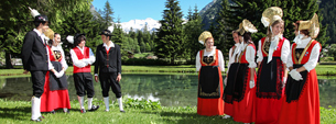
Saint-Rhémy and Étroubles
Two attractive Medieval towns located on the via Francigena
Location
185 km from Annecy, 89 km from Chamonix, 166 km from Geneva, 23 km from Aosta.
Architectural topics
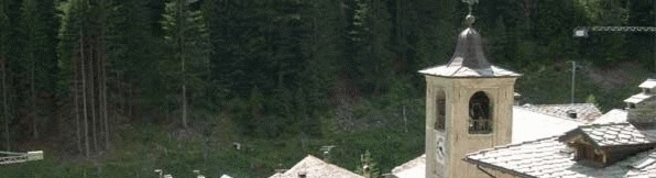
The Medieval villages of Étroubles and Saint-Rhémy are positioned on the Roman road that from the city of Aosta climbed up the slopes of the Pennine Alps (Alpis Poenina), towards Vallese and northern Europe. Like a "pole" along the route, the bell tower of the parish church dominates these characteristic architectural complexes, road villages built along a main through route, where it joins with 2 rivers and in correspondence with the bridges. The secondary routes led to mills and forges.
185 km from Annecy, 89 km from Chamonix, 166 km from Geneva, 23 km from Aosta.
Architectural topics
The Medieval villages of Étroubles and Saint-Rhémy are positioned on the Roman road that from the city of Aosta climbed up the slopes of the Pennine Alps (Alpis Poenina), towards Vallese and northern Europe. Like a "pole" along the route, the bell tower of the parish church dominates these characteristic architectural complexes, road villages built along a main through route, where it joins with 2 rivers and in correspondence with the bridges. The secondary routes led to mills and forges.
The village houses have facades that open onto large entrances and look onto the main road; the entrances lead into internal courtyards or a long corridor, with boxed in stairways, that provide covered access to each floor in the large stone houses, once upon a time fitted with stable and granaries. The construction date and initials of the master builders are carved onto the lintels or forged on wrought iron gates. In the past, these inhabited built up areas had exemptions, that meant locals could act as "marronniers" (guides through the hills of the Great St. Bernard Pass, in winter and summer), were home to a hospice,
and were closed in by a wall that was guarded by patrols of guards and closed in by doors during the night. Via Francigena, up to Medieval times was the only large route that linked Italy with England and passed through Saint-Rhémy and Étroubles; in fact, the main road through these villages was the one taken on foot, horseback or on the back of a donkey from the Great St. Bernard hills to reach Rome.


