Sports
Trekking

Giants trek - Stage 1
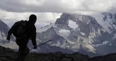
Breathtaking scenery at the foot of Mont Blanc
48.606 km (3750 m D+ 3295 m D-)
See the itinerary on the geobrowser
From the centre of Courmayeur, continue towards the village of Dolonne, take the path that goes to the Arpettaz mountain pasture and from there continue along the path that leads to the Arp Pass (2571 m). From the pass, go down the Youlaz gorge and on to La Thuile (1435 m), from where the signs begin for the Alta Via 2. From there, head towards La Joux and take the waterfall path, which leads to the Deffeyes mountain hut (2500 m), then continue towards Passo Alto (2857 m) and go down to the Plan de l'Arolla and the Cosimo Zappelli Bivouac (2275 m). Continue to Promoud mountain pasture (2022 m), from where the signs start out for the Crosatie Pass (2838 m). From the path, continue round the mountainside to Fond Lake (2338 m) and Planaval (1554 m). From Planaval you can reach the Valgrisenche (1660 m).
Don't miss: View over the Mont Blanc range - Rutor waterfalls - Rutor Lakes - Fond Lake
Suggested program: three days
Fist day: from Courmayeur to La Thuile ((17,085 km)
D+ 1364 m - D- 1113 m
Trekking time: 6h40
First day map
Second day: from La Thuile to Plan de l'Arolla, La Salle (14,500 km)
D+ 1399 m - D- 590 m
Trekking time: 6h15
Second day map
Third day: from Plan de l'Arolla, La Salle, to Valgrisenche (17,050 km)
D+ 987 m - D- 1592 m
Trekking time: 6h45
Third day map